St Luke's Way (East)
St Luke's Way
The eastern Pilgrimage of Hope Way from the Cathedral Church of St John the Baptist in Norwich to the Cathedral Church of St Barnabas in Nottingham via the National Shrine of Our Lady at Houghton St Giles and the Pontifical Shrine of Our Lady of Walsingham at King's Lynn.
Patron: Julian of Norwich (c. 1343 – after 1416) English anchoress, mystic and theologian.
Julian's writings, now known as Revelations of Divine Love, are the earliest surviving English-language works attributed to a woman. They are also the only surviving works by an anchoress in English. Her feast is celebrated on 13th May.
Overview
St Luke's Way starts at the Cathedral of St John the Baptist, Norwich, leaving the city along the Marriotts Way, crossing the River Wensum towards Cawston, then taking the Pilgrim Cross route to Walsingham along country lanes to the National Shrine to Our Lady at Houghton St Giles. From Walsingham the Way follows tracks and lanes to Dersingham and then crosses the Sandringham estate to King's Lynn. The Way continues alongside the Great Ouse to Wisbech, then across fenland to Spalding and Bourne. The Way uses roads and footpaths to navigate the rolling countryside of Kesteven to Grantham, then follows the Grantham canal near Belvoir Castle across farmland to Bingham, joining the Trent Valley Way at Radcliffe, to arrive at St Barnabas' Cathedral in Central Nottingham.
Essential facts:
- Route length: 155.4 miles
- Ascent: 1,883 ft
- Peak elevation: 443 ft (the route is generally flat)
- Average walk day length: 15.5 miles
- Average walk day duration: 6 hours
- First walking day: Thursday 4th September 2025
- Number of walking days: 10
- Number of rest days: 0
- End date: Saturday 13th September 2025 at St Barnabas' Cathedral, Nottingham
- Pilgrims are invited to join the Solemn Mass for the Feast of the Exaltation of the Holy Cross at 11.15 on Sunday 14th September at St Barnabas' Cathedral.
St Luke's Way route
For details of the day pilgrimages and parishes visited see below
NB REGISTRATION FOR DAY PILGRIMAGES HAS NOW CLOSED.
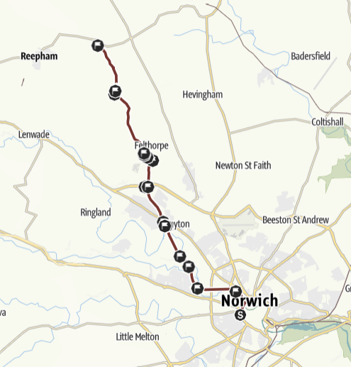
Stage 1: Norwich to Cawston, Thursday 4th September 2025
 THE ROUTE IN DETAIL
Walk overview
From St John’s Cathedral the route descends to the Wensum valley to the start of Marriotts Way (1 mile), a cycle/footpath following the line of the old railway. This passes footpath/road to Costessey (5 miles) proceeding to Drayton (6.5 miles). After footbridge over ring road (8.2 miles) the route leaves the Marriotts Way to take minor roads to Felthorpe (10 miles), and Eastgate (14 miles)
Details of the walk
Distance: 13.3 miles
Approximate time taken: 6 hours walking
Ascent: 157 ft
Where to join: The Cathedral of St John the Baptist, Unthank Rd, Norwich, NR2 2PA
Time walk starts: 10.45 (after 10am Mass)
Where walk ends: St Agnes Parish Church, Church Lane, Cawston, NR10 4AJ
Approximate time walk ends: 5pm
Accessible sections: Marriotts Way in Norwich (1 mile to 3 miles) (Sustrans pedestrian/cycle path) has a good surface as far as Hellesdon Road (3 miles).The next 3 miles from Hellesdon Road as far as Drayton (6 miles) is adequate for buggies.
Shorter walk options
St John’s Cathedral via Marriotts Way cyclepath to Drayton (c 6 miles from start, eta 1400). Return options:
Retrace steps along Marriotts Way at any point or catch 28/29/X29/30A bus from The Cock, Drayton Road to Norwich or arrange own pick up by car e.g. from Tesco Drayton
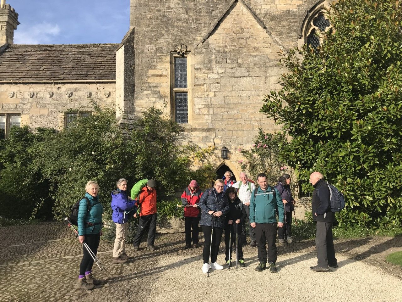
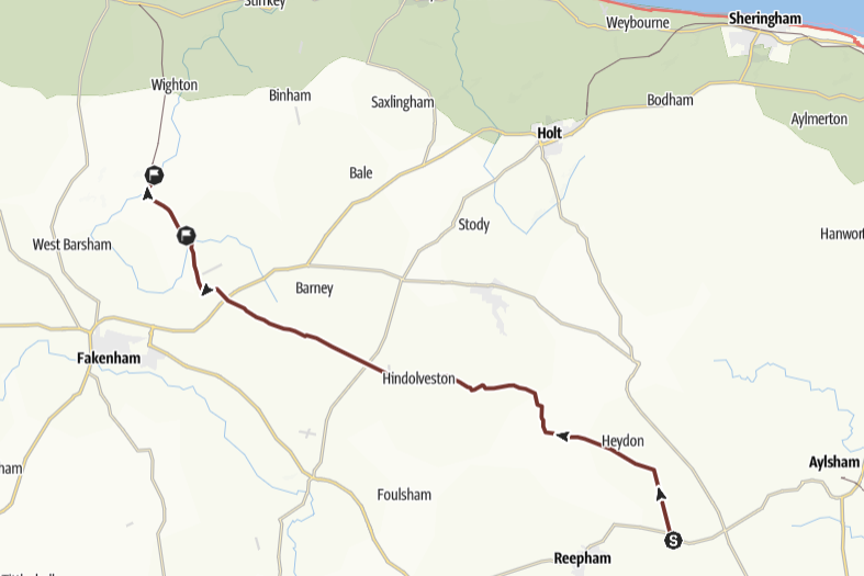
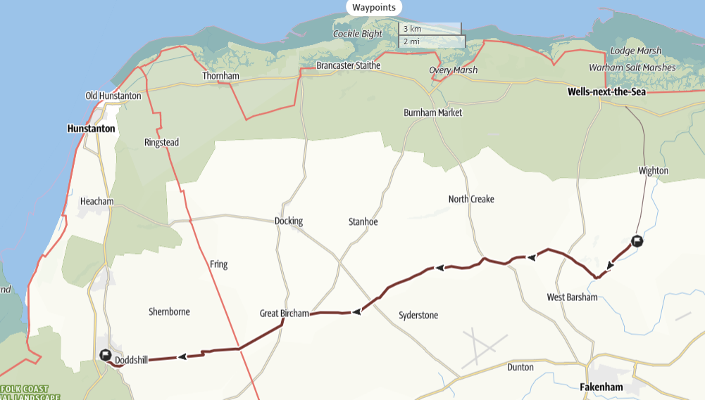
Stage 2: Cawston to Little Walsingham, Friday 5th September 2025
 THE ROUTE IN DETAIL
Walk overview
From Cawston (with its stunning medieval church) the route follows the Pilgrim Cross route via minor roads all the way to Walsingham, following the Heydon estate (3 miles) then through the villages of Thurning (6), Hindolveston (9) Fulmodeston (12), Little Snoring (15) and Great Snoring (17) before descending into the little valley of Walsingham
Details of the walk
Distance: 17.4 miles
Approximate time taken: 7.5 hours walking
Ascent: 154 ft
Where to join: St Agnes Parish Church, Church Lane, Cawston, NR10 4AJ
Time walk starts: 9.30am
Where walk ends: The Annunciation Catholic Church, Friday Market, Little Walsingham, NR2 6DB
Approximate time walk ends: 5.30pm
Accessible sections: As the route is entirely on minor roads it’s not suitable for buggies or wheelchairs.
Shorter walk options
No viable short walk options except by retracing steps along route back to Cawston (route is entirely on roads)
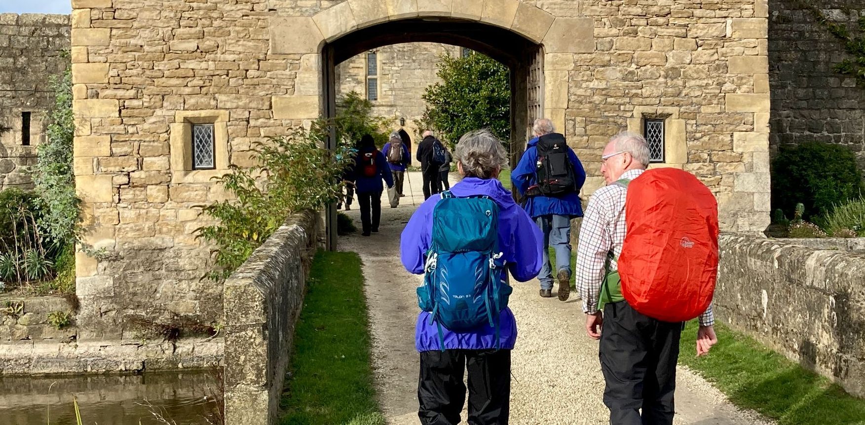
Stage 3: Little Walsingham Dersingham, Saturday 6th September 2025
 THE ROUTE IN DETAIL
Walk overview
The route gently climbs out of Walsingham to head due West along long, straight minor roads and (muddy) farm tracks via the villages of South Creake and Bircham to reach the small town of Dersingham just north of the Sandringham estate. A long day but is fairly straightforward.
Details of the walk
Distance: 18.2 miles
Approximate time taken: 7.5 hours walking
Ascent: 295 ft
Where to join: The Annunciation Catholic Church, Friday Market, Little Walsingham, NR2 6DB
Time walk starts: 8.45 am
NB Mass at 9.30 in the Slipper Chapel at Houghton St Giles
Where walk ends: St Cecilia's Catholic Church, Mountbatten Rd, Dersingham, PE31 6YE
Approximate time walk ends: 5.30pm
Accessible sections: Holy Mile between Catholic and Anglican shrines in Walsingham, otherwise the route is not suitable for wheeled access). The Holy Mile follows old railway track – has a firm even surface.
Shorter walk options
Walsingham Market Square to the Catholic National Shrine along the Holy Mile (firm even surface) c 1.5m eta 1000.
Return options: Retrace steps or
36 Bus to Walsingham or Arrange own pick up by car
Stage 4: Dersingham to Kings Lynn, Sunday 7th September 2025
 THE ROUTE IN DETAIL
Walk overview
The route leaves Dersingham on pavements then follows along the broad verged minor roads of the Sandringham Estate. Crosses the busy A149 (traffic island) and then follows footpaths and tracks to Castle Rising. Forest tracks through Ling Common, then pavements through the outskirts of Kings Lynn.
Details of the walk
Distance: 10 miles
Approximate time taken: 5 hours walking
Ascent: 125 ft
Where to join: St Cecilia's Catholic Church, Mountbatten Rd, Dersingham, PE31 6YE
Time walk starts: 10.30am
Where walk ends: Our Lady of the Annunciation Catholic Church, N Everard St, King's Lynn, PE30 5HQ
Approximate time walk ends: 3.30pm
Accessible sections: Dersingham village has a pavement route from St Cecilias to Petals tea rooms on opposite corner of village. NB Cars may be parked on pavements making access difficult.
Shorter walk options
From St Cecilias to Sandringham tea rooms (c 2 miles, eta 1100) via pavements in town and verges at side of road
Return options: Retrace steps or
35 Bus to Dersingham or Arrange own pick up by car
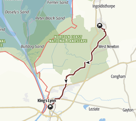
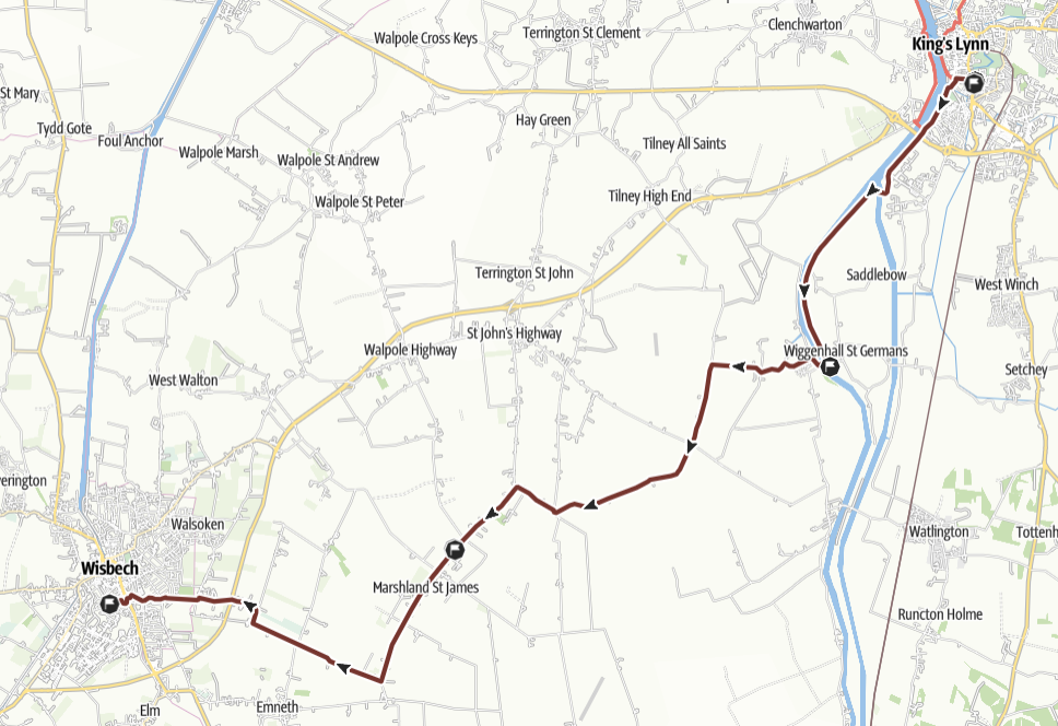
Stage 5: Kings Lynn to Wisbech, Monday 8th September 2025
 THE ROUTE IN DETAIL
Walk overview
Assuming Mass at c 0900 (tbc), then 1000 start. From Our Lady of the Annunciation (with its pontifical shrine) the route joins the towpath beside the Great Ouse, tarmac surface for 3km as far as the power station then a grassed track to St Germains church (medieval pew ends showing sins and sacraments). Minor roads lead through the Fens via a succession of small, long villages to Wisbech.
Details of the walk
Distance: 16 miles
Approximate time taken: 7 hours walking
Ascent: 75 ft
Where to join: Our Lady of the Annunciation Catholic Church, N Everard St, King's Lynn, PE30 5HQ
Time walk starts: 10am
Where walk ends: Our Lady & St Charles Borromeo Catholic Church, 69 Queens Rd. Wisbech, PE13 2PH
Approximate time walk ends: 5pm
Accessible sections: At the start of the route there is 3km flat towpath alongside of Great Ouse past the paper factory
Shorter walk options
From Our Lady, London Road along towpath (metalled) alongside of Great Ouse past the paper factory to the power station (2 miles, eta 1045) or on grass footpath to St Germans (5 miles, eta 1200)
Return Options: Retrace steps or 46 bus from St Germans or Arrange own pickup by car.
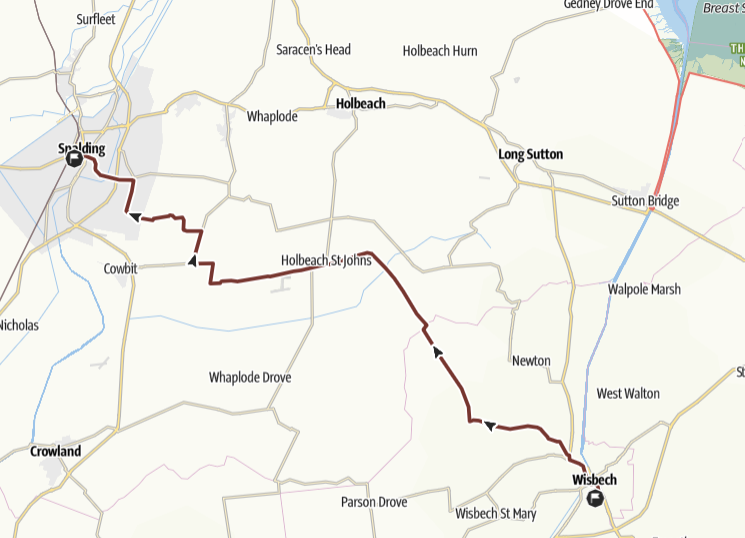
Stage 6: Wisbech to Spalding, Tuesday 9th September 2025
 THE ROUTE IN DETAIL
Walk overview
From Our Lady & St Charles Borromeo Church, the route visits the town centre before crossing the Nene and heading to the village of Leverington through park, main roads and tracks. After this the road follows minor fenland roads, quiet for the most part in a series of zig zags towards Spalding.
Details of the walk
Distance: 21 miles
Approximate time taken: 9 hours walking
Ascent: 75 ft
Where to join: Our Lady & St Charles Borromeo Catholic Church, 69 Queens Rd. Wisbech, PE13 2PH
Time walk starts: 8.30am
Where walk ends: The Immaculate Conception & St Norbert Catholic Church, 52 St Thomas Rd, Spalding, PE11 2XX
Approximate time walk ends: 5.30pm
Accessible sections: The route is entirely on fenland minor roads, some of which are busy so is unsuitable for wheeled access.
Shorter walk options
No viable short walk options - it's a very long day, entirely on roads
Stage 7: Spalding to Bourne, Wednesday 10th September 2025
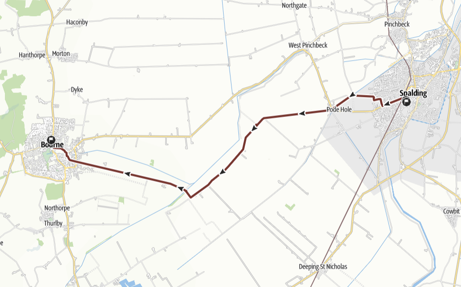 THE ROUTE IN DETAIL
Walk overview
The route leaves central Spalding on the pavement beside the main road, then through a housing estate to a footpath beside Vernatt’s Drain to Old Pode (3 miles). A very long, straight, minor road runs alongside Counter Drain passing LWT bird reserve (5 miles) to turning after Tounge End (7 miles). South Fen Road then leads directly to Bourne, caution - heavyweight lorries on minor road after the recycling centre (9 miles)
Details of the walk
Distance: 12
Approximate time taken: 5 hours walking
Ascent: 108
Where to join: The Immaculate Conception & St Norbert Catholic Church, 52 St Thomas Rd, Spalding, PE11 2XX
Time walk starts: 9.30am
Where walk ends: St Gilbert's Church, 3 St Gilbert's Rd, Bourne, PE10 9XB
Approximate time walk ends: 3.30pm
Accessible sections: The first 1.5 miles of the route is all on pavements as far as Monks Park Primary school, although beside the main road.
Shorter walk options
Immaculate Conception & St Norbert via pavements/footpath but mostly minor roads to Willow Tree Fen (5 miles, eta 1130).
Return Options: Arrange own pickup by car.
Stage 8: Dyke to Grantham, Thursday 11th September 2025
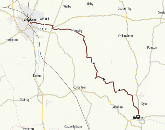 THE ROUTE IN DETAIL
Walk overview
Route leaves Dyke on footpath to Hanthorpe via Morton (2 miles). Minor roads, tracks, footpaths lead to Irnham (7.5 miles) then Ingoldsby (10.5 miles), and Ropsley (14 miles) before crossing the busy A52 and B6403 roads to follow road north of the army barracks, with an excellent view over Grantham before descent into the market town.
Details of the walk
Distance: 20.6 miles
Approximate time taken: 8.5 hours walking
Ascent: 430 ft
Where to join: The Wishing Well Inn, 21 Main St, Dyke, PE10 0AF
Time walk starts: 9am
Where walk ends: St Mary's Catholic Church, 1 N Parade, Grantham, NG31 8AT
Approximate time walk ends: 5.30pm
Accessible sections: This stage is not suitable for wheelchairs or buggies.
Shorter walk options
No viable short walk options - it's a very long day, almost entirely on roads
Stage 9: Grantham to Bingham, Friday 12th September 2025
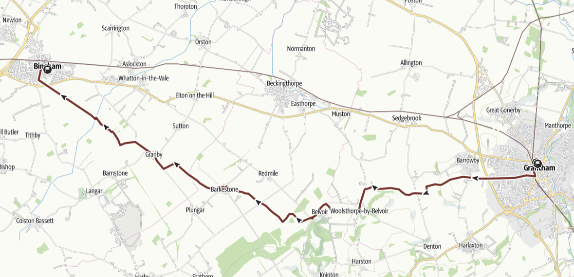 THE ROUTE IN DETAIL
Walk overview
Route leaves Grantham on pavements, crossing bridge over A1 to footpath (2.5 miles) leading over hill and down to Grantham canal (4 miles). Towpath leads to the canalside “Duck at Woolsthorpe” pub (5 miles). Minor road then pavement into Woolsthorpe then footpath over fields to Belvoir. Short road section to Belvoir Castle car park (8 miles) (small café, toilets). Poor footpaths to Barkstone (11 miles) then very muddy track to Granby (14 miles). Footpath joins Bingham Linear Park disused railway (15.5 miles) leading to tunnel under A52 outside Bingham (17 miles).
Details of the walk
Distance: 17.1 miles
Approximate time taken: 8 hours walking
Ascent: 344 ft
Where to join: St Mary's Catholic Church, 1 N Parade, Grantham, NG31 8AT
Time walk starts: 9am
Where walk ends: Bingham Townhouse Hotel, 15 Market St, Bingham, NG13 8AB
Approximate time walk ends: 5pm
Accessible sections: The start of route from Grantham is on well maintained pavements.
Shorter walk options
St Mary's Catholic Church, Grantham to The Duck at Woolsthorpe via pavements, footpaths and canal towpath (5 miles eta 1100).
Return options: Arrange own pickup by car or 9 Bus Woolsthorpe to Grantham NB very infrequent
Stage 10: Bingham to Nottingham, Saturday 13th September 2025
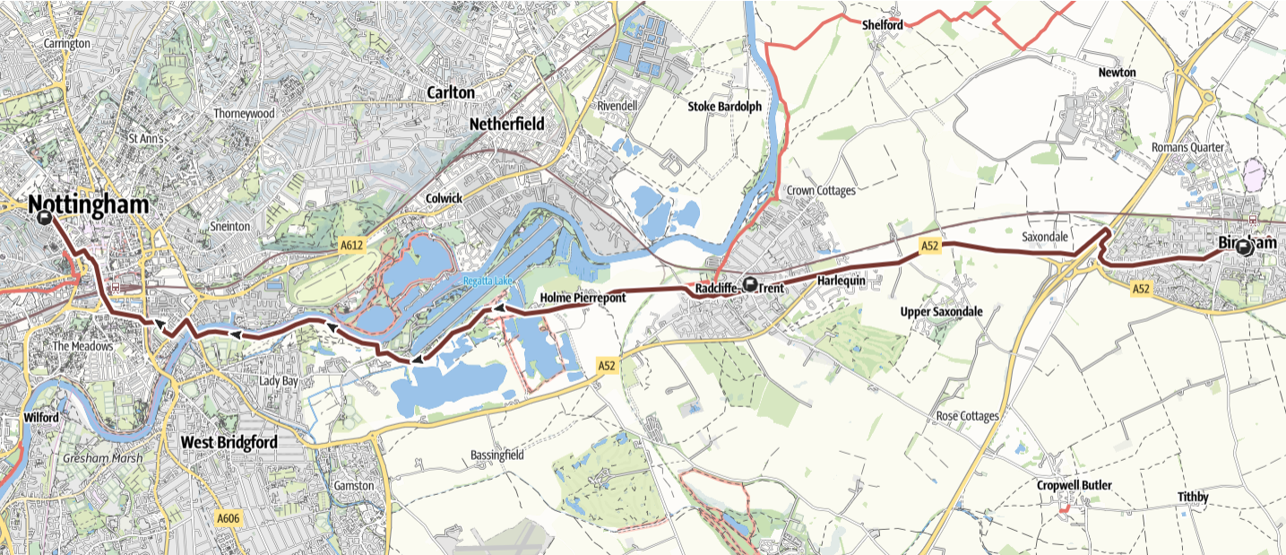 THE ROUTE IN DETAIL
Walk overview
Route follows pavements from Bingham to Radcliffe, with lunch stop at St Annes Radcliffe. Pavements lead to minor road / track to Holme Pierrepoint, then minor roads to path beside river Trent, crossing at Lady Bay Bridge or Trent Bridge and from there following pavements via Railway station and Nottingham Castle to St Barnabas’ Cathedral.
Details of the walk
Distance: 10.6 miles
Approximate time taken: 5.5 hours walking
Ascent: 230 ft
Where to join: Bingham Townhouse Hotel, 15 Market St, Bingham, NG13 8AB
Time walk starts: 9.30am
Where walk ends: St Barnabas Cathedral, N Circus St, Nottingham, NG1 5AE
Approximate time walk ends: 4pm
Accessible sections: Radcliffe (4.5 miles) to Nottingham (12 miles): much of this route is via pavements and tracks though there is a minor road section around National Water Sports Centre between Holme Pierrepoint and the River Trent.
Shorter walk options
St Annes Radcliffe to St Barnabas’ Cathedral Nottingham (6.5 miles, start c 1300, eta c 1530-1600) Pavements and track to Holme Pierrepoint then minor road skirting National Water Sports Centre to towpath beside River Trent, then city pavements to Cathedral. Return options: Arrange own pickup by car or
Train or Bus Nottingham to Radcliffe or Bingham